Tuesday, July 31, 2007

June 2007 - Santa Teresa di Gallura, Sardinia - A Stone's Throw from Corsica

After a week based in Castelsardo, we packed up Smurfette and headed towards our next home base, Palau, in the international jet-set playground along northeast coast of Sardinia known as the Costa Smeralda (or Emerald Coast). On our way, driving northeast along the coast, we stopped in the town of Santa Teresa di Gallura and spent the greater portion of the afternoon enjoying its beautiful beaches and marveling at its spectacular Capo Testa - the point on Sardinia closest to the island nation of Corsica just north of Sardinia across the straits of Bonifacia.

Just before we arrived in Santa Teresa di Gallura, we stopped at Spiaggia Rena Maggiore, the beach on the windy west side of Capo Testa. The water was pretty rough and it was a bit early in the day so we didn't go in and hopped back in the car to continue towards the city.


Santa Teresa di Gallura, a small colorful fishing village on the northeast tip of Sardinia, was inhabited in Roman times and later made important by the Pisans. The current town was built in the 1800s during the Savoy period of rule. We parked Smurfette, trusting she'd look after our worldly possessions for the day, and headed into town. We came upon this charming block and pizzeria just up the hill from the beach and decided to carb load for the lazy beach afternoon ahead of us.

Afterwards, we headed down to Spiaggia Rena Bianca, known for its golden, powdery sand and the granite cliffs that surround it and keep the water calm. We followed this little guy down the steps to the beach.
The water reflected various shades of blue and green yet was amazingly clear. Behind us you can see one of the rocky crags that form the cove and the large dark rocks scattered along the soft sandy sea floor.
Casandra went in first, as usual. You can see some of the granite rocks that protect and nearly enclose this cove behind her on the left and Corsica in the distance.
After a couple of hours on the beach, we packed up our gear, anxious to see the nearby Capo Testa, which we'd heard was one of the most impressive capes in Sardinia. As we climbed back up the hill towards town, we snapped this last shot of the cove where you can really see how the rocky arms of the hill wrap around and protect it.
As we walked on the cliffs along the shore towards Capo Testa, we passed two beautiful coves that we weren't how to reach except by boat.
Here's a close-up of the first one.

And here's the second one.
Capo Testa is a dramatic jagged promontory at the northern tip (or "head") of Sardinia, connected to the mainland by a thin sandbar that extends off the northern coast. These picture hardly do justice to the massive size and depth of this rocky gorge - we're actually standing on a cliff nearly 1000 feet above sea level!
It made me feel really really small. This particular portion of the cape was the site of an ancient Roman rock quarry. Here, the Romans mined the granite that was used for many of their impressive architectural feats, including the massive columns of the Pantheon.

Here is a close-up of the massive granite rocks with the remains of the Roman settlement on top.

From this point of Capo Testa, you can see the white cliffs of Bonifacio in Corsica only 7.5 miles to the north.

Casandra says only Hawaii has natural beauty that rivals this. I haven't been to Hawaii or seen anything even remotely close. The Emeral Coast, our next destination, is supposed to be amazing but I can't imagine it topping this!

June 2007 - Isola Rossa, Sardinia - Pink and not an Island

Another day trip we took from Castelsardo was to the town of Isola Rossa (Red Island), which is neither red nor an island but was nevertheless named after the rose-colored rocky island just off its shore. Because the coast in this northern region of Sardinia is lined with jagged rock formations out of which roads could not easily be carved, we had to drive inland, around a mountain, over the River Coghino, and back towards the coast to get to Isola Rossa, which, as the next town northeast along the coast, is actually quite close to Castelsardo as the crow flies.
The mountains that slope down to the sea form rose-colored crags that have been sculped into strange shapes by wind erosion. Here's our first view of Isola Rosa, a small fishing village, and its cove protected by jagged pink rocks.

We first stopped at this beach on the west, protected side of Isola Rosa where the water was very calm.
After hanging out on the beach for awhile, we headed over to the east side dominated by those amazing pink rocks . . .
. . . and this 16th Century Spanish tower.

From this side, we got a closer look at the island after which the town was named.

The water was a lot rougher on this side but we enjoyed the lively waterworks spectacle of the the emerald sea crashing against the pink jagged rocks.

We (I) climbed all over the rocks, searching for the perfect secluded cove at which to enjoy the rest of the afternoon.

As we continued east along (and over) the rocks, the water kept getting more and more beautiful and colorful! The sloping mountain in the background is Monte Tinnari.

We finally found our cove, almost completely surrounded by the pink rocks, making it somewhat difficult to approach but all the more private as a result.
We carefully climbed down to the water, which was crystal clear . . .
and almost completely still, . . .
connected to the sea only by this narrow strip cut out of the rocks.
From our cove, we also had a great view of the Spanish tower perched atop the rocks.

June 2007 - Stintino, Sardinia - The World's Largest "Swimming Pool"

We had heard that there was a great beach in the small village of Stintino near the northwestern tip of Sardinia so we headed west along the coast to check it out. The beach faces north towards the tip, known as Capo del Falcone, and the island of Asinara just off the coast.

On our way, we stopped at il Santuario di Monte d'Accoddi - one of the most ancient archaeological sites in all of Sardinia, dating from the Copper Age (2450-1850 BC), even older than all of the nuraghic (conical stone) ruins scattered throughout the island.The sanctuary, in the shape of a truncated, stepped pyramid with a trapezoidal base and supported by walls of stone blocks, is the only example of a megalithic altar in the entire western Mediterranean. Around the altar, there's supposed to be foundations for houses, some sacrificial stone slabs, fallen menhirs, and rock-cut tombs, but it was getting hot and we were anxious to get to the beach (and frankly not that interested). So we hopped back in the car, headed back to the coast, and continued northwest.
We drove straight through the town of Stintino, which was originally a small fishing village and now is a holiday town, to its famous beach, which didn't disappoint. It looked so amazing from the road, we couldn't park and get down there fast enough. Just look at that water!
We found this little sandy spot completely surround by amazing black rocks that kept us perfectly dry yet inches away from the gentle surf lapping in and around us. In the distance on the left is the old Spanish tower that "defends" Capo del Falcone and on the right is the island of Asinara.
This was the calmest water . . .
and by far the largest "swimming pool" that we have seen so far, in Sardinia or anywhere else!
The beach was unbelievably wide and the sand bar was remarkably long. You could walk our almost half way to Asinara island and still only be waist deep.
We hung out here for most of the afternoon and headed back to Castelsardo just before dinnertime. If there wasn't so much to see on Sardinia's north coast, we'd definitely come back for another lazy beach day at this unique beach.

June 2007 - Logudoro, Sardinia - The Arid Valley

From Castelsardo we drove inland to the Logudoro region, which is a wide flat valley in Northern Sardinia.

Our main goal was to visit the Santisima Trinita di Saccargia, the most significant example of Romanesque architecture in Sardinia.
After visiting the Santissima, we took a drive through the valley, the Valledoria, founded by the Doria family from Genoa in the Middle Ages and known for its cattle farming and blacksmiths.
The area is surrounded by amazing pink granite mountains which trap the clouds and keep the valley parched and oppressed by an extreme dry heat.
After a drive through the Valledoria, which owes its present prosperity to the quarrying of granite, . . .
. . . all the while crossing through colorful towns like Ozieri (one of the oldest in Sardinia) above, we arrived in Patada, the historical center for Sardinia's finest blacksmiths famous the world over for their handmade knives. We stopped in one blacksmith's shop to take a look at them. The knives are esquisite, made of ram's horn (for the handle) and hand-forged steel (for the blade).
Pattada is also the site of the Sa Fraigada forest, comprised of skinny, impossibly tall trees that have sprouted from the earth inches from one another. We spent the afternoon hiking through the forest before heading home.
The forest is situated on top of a mountain, overlooking the Valledoria. We took this photo from the edge of the forest looking out to valley.
After taking in the views, we drove back down the mountain, through the Valledoria, and over and around the granite peaks. As soon as we got around these mountains we could see the ocean and feel the change to a cooler, wetter climate.

Sunday, July 29, 2007

June 2007 - Capo Caccia, Sardinia - Neptune's Cave

From Castelsardo we took various day trips including a fascinating tour of Grotta di Nettuno and a walk around Capo Caccia and its bright blue beaches.


Capo Caccia is a promontory which towers above the sea off the Northwest coast of Sardinia.


After arriving at the top of the jagged cliff we climbed down 656 stone steps, known as Escala del Cabirol, to reach the Grotta di Nettuno.
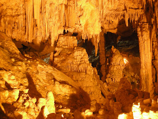
The Grotta are a series of picturesque caves first explored in the 1700s.
The caves extend for 8,200 ft but tourists can only walk through about 650 ft of that.
The caves are thought to be about 500 million years old and covered in whiteish stalagtites and stalagmites.
The caves also contain crystal clear pools formed from the rainwater that runs down through the rocks.